SHERBURNE SOIL AND WATER CONSERVATION DISTRICT
  • Home
  • The District
    • Tree Sale >
      • Tree Sale Store
      • Tree Seedling Care
    • Contact Us
    • Staff
    • SWCD News
    • SWCD Events
    • Webinars
    • Employment Opportunities
    • FAQ's
  • SWCD Programs & Services
    • SWCD Services
    • Financial Assistance
    • Forestry Management >
      • March Pruner Calendar
      • Citizen Pruner Dispatch
      • Urban Forestry Program
      • Tree Survey
    • Water Management >
      • We Are Water MN
      • Aquatic Invasive Species (AIS) >
        • AIS Grant Program
      • Stormwater Program
      • Sherburne COLA
    • Rural Resource Management
    • Water Quality Monitoring
    • Wetland Delineation
    • MN Buffer Requirements
    • Prairie Planting Program >
      • Grams county Park HELP Grant
    • Backyard Conservation >
      • Lawns to Legumes
    • Education & Outreach >
      • Metro Area Envirothon
      • Webinars
      • Elk River Clean Up
      • Little Elk Lake Watershed
    • Well Sealing Program
  • Board of Supervisors
    • Minutes and Agendas
    • Meeting Schedule
    • Legislative Reporting
    • Elections
    • SWCD Partners >
      • MCD Yellow Pages
  • Completed Projects
    • Raingardens
    • Shoreline Buffers & Stormwater Management
    • Native Prairie Installation
    • Pasture & Manure Management
    • Miscellaneous Projects
  • 2021 AIS Meeting Presentations
  • Highlights Videos
  • AIS Presentations
  • video
  • Pollinator Paint Night
  • Rain Gauge Readers
  • Appreciation Dinner
  • Tour Video
Quick Links
  • MN Buffer Law (BWSR)  
  • Check your Property for compliance

Wetland Delineation

Wetlands include a great variety of areas, ranging from the classic duck pond fringed by cattails to areas that look quite different and may even have no surface water for all or part of the year.

Generally speaking, wetlands are identified by three factors:
1. Soils
Wetlands have mostly hydric soils.
These are soils that developed in wet conditions.
2. Hydrology
Wetlands have standing water or saturated soil for at least part of
the growing season.
3. Vegetation
Wetlands have vegetation adapted to wet soil conditions..  

What is a Wetland Delineation?
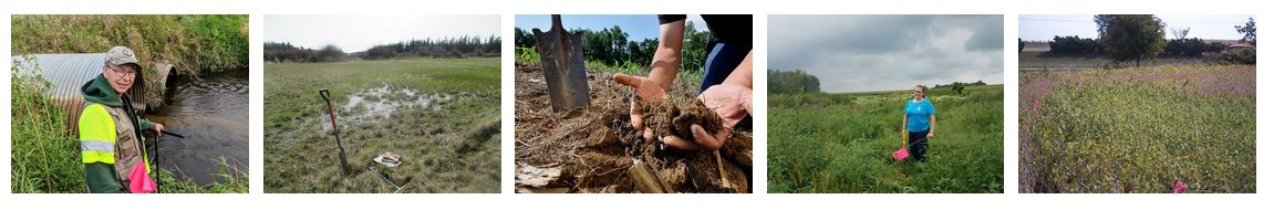
If you need to have a Wetland Review conducted on your property, a consultant first will need to make a site visit to gather field information about the topography, soils and vegetation.
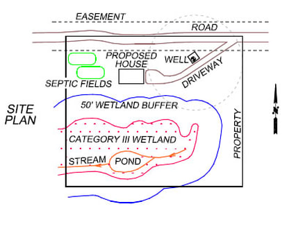
From this, a determination can be made as to whether or not any wetlands are present.

If all three wetland characteristics are present in an area, the boundary of the wetland will need to be established and then marked or delineated with flagging or flagged stakes.
Next the flagging points will need to be located in the field relative to the property boundaries so that a Wetland Delineation Map or Site Plan can be created. The wetland points can be mapped by either using a compass and measuring tape (single family properties only), GPS mapping equipment or a surveyor.

Following this, the wetland will be rated using the Department of Ecology Rating System to determine the quality of the wetland. Depending on which category it is, either a I (high class), II, III or IV (low class), and/or what the water quality and habitat values are, this will determine the width of the required protective buffer. All development must stay outside of this buffer unless mitigation measures are offered.

The last thing a consultant will do is put together a Wetland Delineation Report, to be presented to city or county officials, that summarizes the site, the scientific field data, the wetland and its rating, and which includes a detailed site map of the existing and proposed development, and any wetlands and their associated buffers.
Picture

Why do I need a Wetland Delineation?

In 1991, reacting to public concern about Minnesota’s disappearing wetlands, the Minnesota Legislature approved and Governor Arne Carlson signed the Wetland Conservation Act, one of the most sweeping wetlands protection laws in the country.

    Request more information, or schedule a wetland delineation on your property by filling out the form below.

Submit
Picture

Sherburne Soil and Water Conservation District
Sherburneswcd.org     763-220-3434     425 Jackson Ave. NW     Elk River, MN 55330
Open Monday - Friday  8:00 - 4:00, by appointment       Closed on Federal Holidays

Sherburne Soil and Water Conservation Copyright © 2016
  • Home
  • The District
    • Tree Sale >
      • Tree Sale Store
      • Tree Seedling Care
    • Contact Us
    • Staff
    • SWCD News
    • SWCD Events
    • Webinars
    • Employment Opportunities
    • FAQ's
  • SWCD Programs & Services
    • SWCD Services
    • Financial Assistance
    • Forestry Management >
      • March Pruner Calendar
      • Citizen Pruner Dispatch
      • Urban Forestry Program
      • Tree Survey
    • Water Management >
      • We Are Water MN
      • Aquatic Invasive Species (AIS) >
        • AIS Grant Program
      • Stormwater Program
      • Sherburne COLA
    • Rural Resource Management
    • Water Quality Monitoring
    • Wetland Delineation
    • MN Buffer Requirements
    • Prairie Planting Program >
      • Grams county Park HELP Grant
    • Backyard Conservation >
      • Lawns to Legumes
    • Education & Outreach >
      • Metro Area Envirothon
      • Webinars
      • Elk River Clean Up
      • Little Elk Lake Watershed
    • Well Sealing Program
  • Board of Supervisors
    • Minutes and Agendas
    • Meeting Schedule
    • Legislative Reporting
    • Elections
    • SWCD Partners >
      • MCD Yellow Pages
  • Completed Projects
    • Raingardens
    • Shoreline Buffers & Stormwater Management
    • Native Prairie Installation
    • Pasture & Manure Management
    • Miscellaneous Projects
  • 2021 AIS Meeting Presentations
  • Highlights Videos
  • AIS Presentations
  • video
  • Pollinator Paint Night
  • Rain Gauge Readers
  • Appreciation Dinner
  • Tour Video